Tuesday 28 July 2009

Postscript 2 - Presenting the Money!


Lindsey and I went down to Cornwall on July 17th and met John and Yolanda at Precious Lives where we formally handed over a wad of cash, representing the £11,047 plus £1195 GiftAid that we have raised.

We saw the plans for the new hospice, which will be on a hill overlooking Truro and looks like it will be a very nice building indeed. It will be great to know that we contributed when we see it being used.

Niether of us has suffered ill-effects and memories of the dark days yomping along under leaden skies are fading. In fact, John is getting decidedly euphoric about it all! Well, I'm very glad he has happy memories. So do I.

Thursday 28 May 2009

Post Script

I have taken over 1,000 high resolution photographs, some of which are very beautiful and will be making the best of these available in due course. I also hope to publish something based on the whole experience and will keep anyone informed who is interested.

If you would like a print or copy of a photograph, or for further information about our walk, please contact Doug Kennedy on dgkennedy@alloverde.com.

Wednesday 27 May 2009

Day 51 - Last Stage to John O'Groats


The Pics from the top:
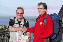
* Doug, Yolanda and John at the finishing post just after we'd arrived;
* Ackergill Tower in Sinclair's Bay (a castle offering very luxurious accommodation);
* A deserted croft in the bleak countryside during our last day.

Day 51 - Monday May 25th. Our final day dawned dull and damp: dreich as the Scots say. We set off by car after breakfast, returning to The Old Smiddy pub and were on our way, for the last time, before 9am. Physically, we seem to have managed well: our legs and feet have become hardened to the task and hills are little effort. John's shin splint pain has gone and there seems to be no sign of wear taking it's toll apart from some small aches that would be cured by a day or two's rest. We were accepting of what was to be a pretty boring day, what with the dull weather masking the distant views, and the countryside becoming more level and bleak.

For some time now, we have walked separately most of the time, meeting at odd points during the day. My natural walking speed is a bit faster than John's,but then I stop a lot to take photographs or check out some flower or bird while John tends to keep a steady pace going. In fact he said that he felt he had become a 'walkamaton', and it is true that, once we have got a rhythm going, the feet just seem to step out one after the other for as long as necessary. Today we were set on walking together and finishing as we started, together, and it made a pleasant change. We somehow had more to say to each other, reviewing the previous weeks, commenting on our surroundings and joking. However, as we approached Wick, the weather closed in further and it drizzled steadily.

At Wick, John saw Yo and the car in the Tesco carpark as we passed, so we sat and had a cup of coffee and Yo said that she had visited thegolf clu which was right by the beach and there it seems you can walk along it. We checked with a local who said that we could go a few miles towards the village of Keiss on it, which would be much more pleasant than the road. So we got to walk on a sandy beach with the grey sea gently lapping at our feet for about half an hour and were feeling really happy. We were hopeful of reaching Keiss this way, but were stopped by a broad stream that emerged from the dunes in which the water was brown with peat, and you couldn't see the bottom, and it looked too deep to wade anyway. I did go in above my knees and hadn't got to the deep bit, so decided to go no further. We were therefore forced to follow the 'stream', which looked more and more like a river, and to find our way around and over deep drainage ditches, tussock grass, fences, gates and finally a field of oats before getting back onto the road. Sadly this has cost us about half and hour, but we had enjoyed the change.

Now it was a solid and boring yomp to the finish. The last 9 miles seemed to take a very long time and for part of it, we were in a thick, damp mist. Eventually, after 4pm, we saw the little tower of the old John O'Groats Hotel in the distance and knew our challenge was almost over. We didn't skip down the last mile, but were certainly elated and relishing the fact that we had done it.

The finish is the old hotel with the signpost pointing to Lands End in place whilst the photographer is there: as at Lands End, they take the top off when he's not. John and I touched that post at the same moment, then the photographer put LEMUSICALJOG 1,024 MILES onto the sign post and we had our photo taken. We thanked Yo for her days and days of support, then went to the cafe for a celebratory toast in good Scotch Whisky.

Tomorrow, I will hitch a lift with John and Yo to Inverness, then take the train home whilst they drive on back down to the south-west.

In conclusion, we feel that we have succeed in completing the challenge and done it well. We kept up 20 miles per day average, finished 9 days in advance of our original limit and have experienced some of the most wonderful countryside in the UK on the way. Our route had been overall a good compromise between scenic and direct and everything had gone to plan. We had certainly demonstrated that 60 is no limit to physical stamina and strength. Personally I have proved to myself that the long walk I had talked about and thought about for a long time was within my capabilities and, although it is not something I would want to repeat, is an experience that I will value forever. It has not been one of John's ambitions, but he seemed happy to have succeeded in the challenge and was making noises about finding another, very different challenge for the future.

If you have not done so, please do SUPPORT OUR CHOSEN CHARITY to build a children's hospice in Cornwall. This can be easily done by logging on to www.justgiving/johndrinkwater. This makes our efforts worthwhile in the wider context and is the main reason that I put so much into the Twitter and Blog.
If you HAVE already supported us, THANK YOU VERY MUCH.

Finally, I would like to dedicate my walk to my lovely wife, Lindsey, who so readily agreed to my doing it so soon after our marriage at a great cost to herself in terms of spending weeks alone. She has been brave and supportive throughout, so thank you my darling.

Monday 25 May 2009

Day 50 - Newport to Thrumster


The Pics: Dunbeath Castle; The way buildings were around here in Caithness; Typical coastal view.

Day 50 - Sunday May 24th. It was a lovely morning; clear and sunny with whispy clouds. We had been staying in a holiday-let place in Tain for 3 nights, so cleared everything out and set off before 9am. We drove back up the A9, 46 miles to the spot where we stopped yesterday above Berriedale and were underway before 10. Our goal today was a pub called The Old Smiddy at a village called Thrumster. Many of the place names in this region end with 'ster', which comes from the old Norse for homestead. Apparently Thrumster means 'homestead on the hill'.
The second from last day is not the last day, so ends with another day to go, so it was something to be got through before we could finish. We are both pushing our bodies in order to finish earlier - we really should have taken a rest day at Fort William or Drumnadrochit, but we will manage 2 more 20 mile days. The countryside gets flatter from here, so the walking won't be difficult but it is all on the road, and will become less interesting, but we have the end in our sights.
The views all day were pleasant, with rolling green fields containing cattle or sheep leading to the expanse of the North Sea, and the huge sky to our right, and to the left, fields leading to brown heather-covered hills, the foreground usually dotted with houses. Settlements were becoming smaller and more and more remote. Life up here must be very hard in winter: I'm told that, in fields on the cliff tops children minding the sheep were tied to stakes in the ground so they didn't blow away during storm.
We came across another large castle, hanging onto a cliff at Dunbeath, but there really was not much else of note. But at least it was sunny, so what we saw looked its best. I have been surprised, and a bit disappointed, that we haven't come across any other End-to-End walkers going the other way: in fact there have been no walkers, but lots of cyclists on the road.
I reached the Old Smiddy at 4:30pm, greatly relieved and pretty tired, and John arrived a bit later in a similar state. The pub is homely but a bit run-down, but it has an atmosphere and in the bar a few local men were drinking, listening to the football results and also getting into little arguments about odd things: whether Sunderland was south or east of Newcastle (it is both), or whether the Harris accent is stronger than other Hebridean accents. We had supper there before Yo collected us at 7pm. I found it rather dispiriting to drive the 21 miles to John O'Groats to our hotel as we now know what is coming tomorrow - it gets flatter. When I got to my room I felt too tired to do anything but go to bed and watch the TV till I went to sleep.
One day to go.

Day 49 - Brora to Newport (Caithness)


The photos: Brora Harbour; Two oyster-catchers at their post; a beach near Brora; Helmsdale Harbour.
Day 49 - Sat May 23rd. The 0ver-riding thought in my mind as I was preparing to depart on another 23 mile day that there are only 3 of them left. With Yolanda's support, carrying the gear, cooking and meeting us we are in a very good state, considering that we've walked nearly 1,000 miles. But we are getting weary and need a bit of serious rest and are set on keeping going for this last few miles to our goal.
We were out of the house at 8am, and Yo drove us 24 miles north, up the A9 to Brora and we started walking under a cloudy sky. We walked away from the A9 down to the golf course and the beach, where we were able to pick up a footpath for a couple of miles. Walking on the links golf course next to a beach reminded John of his home in Cornwall. On the beach there were lots of oyster catchers and gulls, flying around and making quite a racket. In one place they had a favourite perch on a series of fence posts an sat there, all in a line.
Once we were back on the A9, that was it for the rest of the day, however, the road was not busy and there were few trucks and vans. The farmland began to be replaced by heather moorland and buildings less frequent: this is a hard country and very far north. A lot of the time, on either side of us, were dark rounded hills which stretched away to the west as far as you could see. To the east an south was the North Sea, grey an quiet today. You could see the dim outline of the eastern peninsula of Scotland in one direction, and in the other, far out to sea, were some oil or gas platforms and a couple of huge wind turbines.
As has become normal, going each at our own pace, we soon split up and I just kept walking the 12 miles to a little town with a harbour called Helmsdale, where I stopped for rest and refreshment. I didn't expect the cafe owner in a place as far north, and out of the way, to be English, but he was. Ran a nice place though and had wifi, so I was able to load up the latest Blog instalment. Other customers kindly expressed and interest and promised to log on an contribute to Precious Lives (www.justgiving/johndrinkwater), which was very nice of them.
John and I both like the feeling at these little places that they are at the 'end of the road' . Every settlement has its own distinct character and, usually, a lot of charm. Of course, it can't be easy living here in the winter, when the weather can be appalling and daylight is very short. But in the summer, even on a dull day like today, there is always something of interest. Helmsdale has a harbour, which looks like it has been beaten about a bit by the sea as one sea wall is only half there. There are several cafes and restaurants down the pretty main street and it sits in an attractive river valley.
There was a steady climb out of Helmsdale on a new EEC funded road (but still no pavement or cycle way), and the road stayed high until the hamlet of Berriedale, where it plunged down to sea level, only to rise up again to our finish point at the top of the hill. Berriedale is deep in a river valley which it follows out to towards the sea, but ends where a huge cliff face with many seagull nests separates the valley from the sea.
Tomorrow we do another 22 miles, then it will be the last day.

Friday 22 May 2009

Day 48 - Tain to Brora


Pics from the top: The bride across Dornach Firth; Swans on Dornoch Firth; Galspie High Street; Dunrobin Castle near Golspie; A seal on a rock.


Day 48 - Fri May 22nd. John set off early at 7:15 in order to be able to take his time and get an earlier finish. I took advantage of the fact that we were in self-catering accommodation and made myself breakfast, then set off at 8:30. We met up several times in the day and finished together at 4pm, which was perfect. The guide books tell you that there is really no alternative on the eastern route but to yomp along the A9: well that is the case sometimes, but there are some excellent escape routes, one of which we found today.
The A9 Tain bypass is a fairly new road, but no provision has been made anywhere on the road here and elsewhere for cyclists and pedestrians. You can walk safely, but it is on grass of variable condition or on the road gutter. Since this is a recognised cycle route and long distance walking route, and there is NO other way to go, I feel it is a disgrace that this has never been dealt with. It is not uncommon: the Lovat bridge over the river at Beauly is decidedly dangerous and has been for many years, and the A82 near Lanark is horrid to walk on to pick just two examples. But what is really disappointing is that when roads are resurfaced or improved, the authorities still completely ignore pedestrians and cyclists. The A9 has room to spare but pavements are only provided across bridges, then stop: why? The government talks about needing to get people out of their cars but execution is patchy at best.
So we had to walk on the noisy A road with big vehicles rushing by, but at least the scenery was gorgeous. On a luminous day like today, with complex cloud patterns and lots of sunshine between the odd shower, the light is fantastic on water. And there is plenty of open water around to display the beauty of our planet. Crossing the bridge over the firth one was treated to views towards the hills, where the waters narrow, to the west and out over the shallow shoals to the sea and the huge sky to the east. On the way I encountered a charity boat push by which the sign said was 'sponsored by the Applecross Inn', but I'm not sure what they were raising money for. The Applecross Inn is an excellent pub on the West coast, opposite Skye.
The walk along the A9 was not very nice, and John found a good alternative route for part of it, using his GPS. I continued on the road to Golspie, where I stopped for a break. I did meet up with John and Yo at another piece of the ubiquitous Thomas Telford's work in the form of a causeway at Loch Fleet. This is called The Mound and its building separated the river Fleet from the salt Loch Fleet (which is a National Nature Reserve now) and shortened the journey north by many hours.
I rested for a while on the Golspie sea front, eating a sandwich, then continued along the road to Dunrobin Castle, but John had realised that a pathway ran all the way from Golspie to Brora along the beach! The castle is the seat of the Earls of Sutherland and from the sea, looks like it was constructed for a fantasy film, or fairytale, with its tapering towers. Below it is a strip of woodland with the densest and bluest bluebells we have seen I think, and then the sea an the clouds. There were lots and lots of birds - mostly oyster catchers, gulls, terns, cormorants - and also seals sunning themselves on the rocks. And there was the sky and the sea and the distance. I took loads of photos and it turned into a really nice afternoon's walk for us. We got to Brora together and Yo was waiting with the car as usual, and we had yet more treats in store.
She took us back to a small road that runs along the south side of Loch Fleet, where we saw lots of seals on a sand bank, and others playing in the water. Then we went on to Dornoch, which is a delightful little town with it's own small cathedral, founded in the 13th century. This is a simple cruciform building of stone, with a single central tower. It is very simple and gracious inside with the most gorgeous stained glass windows. We had a drink and some delicious hors d'oeuvres in the hotel opposite then set off back to our accommodation.
We had taken for granted that the last days were going to be a simple 'yomp', but today we have been bowled over once again by the beauty and magic of this country.

Thursday 21 May 2009

Day 47 - Dingwall to Tain


Pics from the top: Oil platforms in Cromaty Firth; Typical countryside with a church, an oil platform top and The Black Isle in the background; a lapwing in flight; the Still Room at Glen Morangie Distillary.


Day 47 - Thu May 21st. Another bright start to the day, and we set off in the car before 9 to drive the 25 miles to Dingwall. It was interesting seeing our route from this angle, and it didn't look very inviting for walkers. However, the countryside was looking nice in the fair weather and visibility was good. Showers were forecast. We had about 23 miles to do during the day, following the length of the Cromarty Firth to Tain, on the east coast. Unlike yesterday, the route was on minor roads defined as a cycle route, so it was a great deal more pleasant with lots of variety.
The route took us up through some suburbia, the out onto farmland a couple of hundred feet above the Firth and the A9, affording us great views of the water and the Black Isle. The Isle is not an island and is not black, but a very fertile peninsula stretching out to the North Sea between the Moray and Cromarty Firths. Cromarty Firth is a centre for servicing the oil and gas industry, so you could see huge platforms standing out in the water. The countryside here is gentle and varied and very pretty. Down low, it is farms with cattle, sheep and horses, then higher up the hill, there tends to be forest, and at the top, at about 1,000 feet, heather moor. So there was much to enjoy as we put one foot in front of another for yet another day.
We started walking together, and Yo was waiting for us at around 11am by the road with some peppermint tea and biscuits - luxury again! I wanted to visit the Glen Morangie Distillary at Tain and had to get there by 4.15 to get onto a tour, whereas John was more concerned with completing the day at a reasonable pace. So I set off to see if I could do it in time apart from a stop in Alness for a bowl of soup and a roll, walked solidly and fast, arriving in Tain just in time.
One blemish on an otherwise enjoyable walk was that a farmer had decided this would be the day he would move tons and tons of extremely smelly muck about 3 miles along the road we were walking on. There was little other traffic, but the huge tractors thundering up and down the road with big trailers were not only intimidating, but left a foul pong in their wake! Between tractor loads, however, we could enjoy the big skies with ever-changing cloud patterns, the views and the lovely azaleas and lilacs growing in peoples' gardens. Azaleas do particularly well in the damp Scottish climate and we saw some magnificent specimens. I also encountered lots of birds: some lapwings, lots of finches and tits, a yellowhammer, some buzzards and a sweet little bird with a long tail I didn,t recognise, as well as the usual sparrows, pigeons, crows and so on. I attempted to get some action photos with mixed success.
John's slightly more leisurely pace still got him to Tain at an average of 3.1 MPH, including stops: we really are fitter! Tonight we are staying in a holiday let house with plenty of room so can do as we please, rather than fit in with B&B rules.Tain is an attractive and solidly built town of grey and red sandstone. It seems tidy and well managed and has lovely views out to sea and to the northern hills.
Only 4 days to go! This is putting a spring in our steps even though we are both quite tired.

Wednesday 20 May 2009

Day 46 - Drumnadrochit to Dingwall


An old oak at Beauly Priory, and the view over Kiltarlity from the Beauly road

Day 46 - Wed May 20th. 6 days to go and counting. Today we faced 26 miles of road walking, mostly on A roads, which Alistair told us would mostly be pretty quiet and easy to walk on, but it is much nicer walking without traffic. We set off in bright sunshine, down our road with its neat houses, many of which are B&Bs. Then onto the main road and across the bridge over the River Erick next to which lies The Loch Ness Monster Centre and Exhibition. This is garishly advertised with huge bill-boards and we weren't tempted to enter. I had found a route that avoided a dog-leg on the main road which would be a difficult walk without a pavement. The route took us up the hill at this point. In Scotland, you have a 'right to roam' anywhere that there is not a good reason to do so, but it means that 'rights of way' as such are not marked on the map as they are in England. We have found, in fact, that you cannot rely upon paths on the map that are not actual routes: they may be over-grown, or closed, or have changed. So in this case, all we had to guide us were lines that more-or-less matched the ground. The first bit was a path that had shrunk from a route you could drive to a woodland path. However, we navigated this OK, then it should have carried straight to take us to the main road. HOwever, things had changed and there had been some new housing developments so the road went through to those, up a steep hill. At the top of this I realised that we had gone wrong and my back-up route had been obliterated. I will need to inform the Ordnance Survey on my return!
Once we got back on the main road, all we had to do was follow it to Beauly. There was no actual pavement, but there was a grass verge for most of it and it wasn't busy until we got close to Beauly. The countryside was pleasant but all you really wanted to do was to get the miles done as quickly as possible.
Beauly is a nice little town on with a ruined priory and a pleasant stretch of river, however the afternoon's walk was not enjoyable at all: just a lot of road with enough traffic to mean that you had to stay very alert in the sections where there was no footway. There wasn't a lot to see, apart from passing through two villages, crossing a couple of rivers and the light and clouds on some hills to the west. We are very far north now, and the weather can be very unpredictable; there was some snow remaining in streaks on the hills, and at one point late in the afternoon it got very cold and started to hail heavily. Luckily we were inside a pub at Dingwall at the end of our day, but you never take the weather for granted.
Dingwall is quite a sweet town with some fine stone buildings and a real character of its own. It is on the Cromarty Firth (we entered the county of Ross and Cromarty today) and has the huge Ben Wyvis (1006m) as a backdrop to the north-west. I will not be climbing this, however, as it is too remote and difficult to access. The weather forecast is also not very good.
Yolanda came to ferry us back to our B&B and tomorrow we decamp to a self-catering place at Tain on the Dornoch FIrth. Tomorrow's walk will take us over this firth on minor roads, following a cycle route.
Finally, we are into our last few days, and working hard to see the challenge through: this isn't easy! So, if you haven't made a donation towards Precious Lives, and are not planning to do so when we complete, PLEASE COULD YOU CONSIDER MAKING A DONATION NOW, or once we've finished by logging on to www.justgiving.com/johndrinkwater. Thank you very much.

Tuesday 19 May 2009

Day 45 - Bridge of Oich to Drumnadrochi


The pics from the top: View of Loch Ness; Walter Baker and his son Geoff; Canoeist on rapids at Invermoriston


Day 45 - Tue May 19th. We set off after breakfast by car back to Bridge of Oich on a bright morning and were walking before 9:30. We had anticipated a day rather like Monday but our B&B host, Alistair, told us that the walk from Invermoriston, involved a lot of climb and was longer than advertised. The first part of the day to Fort Augustus was along the next section of the Caledonian Canal where the channel seemed to link up a series of small lochs as it was often very wide, and marked with buoys. There were a lot of pleasure craft coming through the series of big locks which was quite an operation as the height climb from Loch Ness is about 80 feet and the lock gates are huge.
For most of the remainder of the day, we would be walking through pine forest on the north side of Loch Ness where you are hemmed in by the thickly planted trees, and get occasional views out across the loch. The hill on this side rises straight up to nearly 1,000 feet and the forest road generally holds a level, it rises and falls, sometimes quite steeply. We encountered quite lot of foreigners walking the Great Glen Way, and I felt that all these pine trees were not a great introduction to Scotland. However there are also long sections of the trail in more interesting and scenic terrain, so it probably works out ok. The W.Highland Way is far more interesting and characteristic however.
Loch Ness is very big and long and doesn't alter much during its length, but in the sunshine it was pleasant enough walking and quite easy when it wasn't climbing. During the morning we came across two men taking a break and got chatting to them. This was Walter Baker and his son Geoff. Walter is 79 years old and doing LEJOG in honour of his deceased wife and in aid of a cancer charity. He left on March 23rd and is looking to finish by the end of May and Geoff has joined him for a week for company. Amazing what people can do if they try!


We met Yo at Invermoriston, where there are some big rapids, and I watched a couple of young men in little canoes going down them. Not easy, and one turned turtle but amazingly righted himself in the midst of the swirling water. We had a very civilised lunch, without rain this time, although there was a big black cloud to the east.
The afternoon involved a great deal of climb, eventually rising to the top of the ridge 1,000 feet above the loch. My computer map system says that it was about 12 miles with 1,300m (4,500 ft) of climb but John's GPS says we did far more. Suffice to say that it was a long and tiring afternoon, but the weather was lovely so we got great views when they were available.
I finished a bit ahead of John, choosing to finish the day on the road which ran steeply down into Drumnadrochit, but he stayed on the Great Glen Way. There was a bridge marked on the map to cross the little river into the village which was no longer on the ground, necessitating a 1.5 mile hike back along the river to the main road. This is a horrible thing to happen after a long and tiring day. Alistair told us that the reason was a neighbour dispute. A London QC bought the land on one side, and that on the other was owned by a property developer. The owner of the bridge objected to the other using it for access so bulldozed it, and since then, the maps have not been updated even though it was several years ago. How stupid people can be!
We finished the day with a little barbeque provided by Yo once more, by the river in Alistair's delightful garden.


Day 44 - Fort William to Bridge of Oich


The top two pics are looking back to the Ben Nevis range, then the pub barge.
Day 44 - Mon May 18th. Starting the Great Glen today, and we really feel we are on the homeward run now. We are going to up our mileage from 20 to 25 per day, which should get us to John O'Groats next Monday 25th! Yolanda has arranged accommodation till the 26th and will carry our kit, ferry us to and from our start and end points and meet us at lunchtime with picnics. This makes life a great deal easier than it otherwise would be, of course, but the challenge is to walk the distance and this simply mitigates the endurance required. If we wanted to spend more time on it, for instance, stretch it out to 60 days or more as we had originally planned, then our goals would be rather different, but we both want to get back to our lives as soon as we can. In particular, I want to get back to my wife of one year!
Grey skies today and showers were forecast. I set off at 8:30 and walked the couple of miles to the canal where John met me. The Caledonian Canal links Inverness in the east with Fort William and the Atlantic Ocean in the west via the Great Glen lochs. It is a much bigger affair than the narrow boat canals that criss-cross England so was built to take bigger boats and cargoes. It brought a great deal of employment and improvement of access to this region when it was built, which must have been a herculean task considering the amount of hard rock that had to be moved without machinery. There are extensive lock systems which, at Fort William, are made up of 9 huge sets of gates. All of this is well maintained but seems to be used for pleasure boating and other leisure activities now. Later on in the day we were to walk on a redundant railway line that was another great 19th century project at the time, to build a mainline standard railway from the east to the west. This failed, apparently, because of competing railway companies not being able to agree and combine their efforts, so it was never completed.
We walked for several miles along the canal, then followed the length of Loch Lochy on the north bank through a pleasant mixed forest. Most forests we walk through are dense coniferous commercial forests, but mixed woodland is far nicer for interest, beauty and wildlife. We were aiming for a hamlet called Clunes for lunch. This was arranged around a very pretty part of the loch and we were surprised to see some rather large houses being built as it s very remote. In fact there seems to be quite a lot of new development in this part of the highlands. Yo was there in the car waiting for us with lunch and, having set up picnic chairs and enjoying some soup, we felt very smug, until the rain stated to fall. However, we did get a little rest and some proper lunch which we will need now we are doing more miles.
Just a few yards down the road, we were greeted by a lady who said she was warden of the trail, offering us a cup of tea or coffee! Had we known, we could have avoided the rain, but as it was we had a chat the continued on our way. The route continued through the woods on the Loch Lochy lakeside for several miles, then turned east and crossed a road and the canal at Laggan. I was hoping for some refreshment, and we found a barge that advertised itself as a pub. Going down into the interior, we came upon a very jolly scene, with lots of hikers and cyclists enjoying a drink and the atmosphere. We had a pint and a toasted tea cake, which were both very welcome indeed and got talking to some people in the bar who donated £25 to our charity - what a thoroughly worthwhile stop! In fact we were in such a good mood, we didn't really mind that it was still raining outside.
The remainder of the walk was the length of Loch Oich along an old railway track that has been long defunct and who's sides are now completely covered with very deep layers of moss. Loch Oich is quite small and pleasant to walk along with some islands and shallow reedy places. There were a few campers trying to get fires going in the wet conditions. We, however, were met by Yo in the car and whisked off to our B&B in Drumnadrochit.
We had a very nice dinner at a local pub/hotel and then I made an attempt to play in the bar, which rather fell flat, so I stopped and we went back to our lodgings. Disappointing for the second time, but surprising as in Scotland in my experience live music goes down pretty well.
I did about 26 miles today and John a bit less as I had the extra bit at the beginning.

Sunday 17 May 2009

Day 43 - Kinochleven to FOrt WIlliam


Pics from top to bottom: Looking West over Loch Leven to Glen Coe mts. ; The West Highland Way 1 hour from Kinlochleven; me having a glorious time on top of Stob Ban (I walked around the ridge that is seen behind me in the photo); View up to Sgur a Mhaim (nearest) and Stob Ban from Glen Coe.
Day 43 - Sunday May 17th. Today was great! What a bonus, getting an TOTALLY rain free day in this part of the Highlands, particularly with an inffy weather forecast. I had a blast, walking up 1,000 metres, then doing an entire ridge and 2 Munroes in beautiful weather. Magic.
John is happy because Yolanda has joined us and is going to be our fairy God-mother for the next 8 or 9 days as we complete this. She's a real hero for doing this.
All of the peaks were clear of cloud and standing out proud. We had a leisurely start at 10am as we only had about 14 miles to do to get to Fort William. Yolanda was coming up to support us in the final week and was expected at around 4pm, so we werent in a hurry. The Way climbed steadily up to the north of Loch Leven and we began to get some nice views of the water and the mountains beyond. In fact, it became apparent that all of the peaks were clear of cloud, the weather seemed settled with light winds and it was a perfect day for going high. I checked the map and decided to take the high road; that is, to climb up to the Stob Ban peak and ridge which ran parallel to the Way, but a about 2000 feet higher. I checked with John and told him my plans, and to expect me between 4 and 6pm, and set off climbing steeply up through the moss and heather.
Stob Ban is a 999 metre Munro that stood out directly above where I started, and there were no actual paths up to it from this side, so I did what I normally do in such situations, which is take the direct route up. Luckily, the ground was fairly even and the vegetation not too high so although steep, I made good progress. As I climbed, the views opened out and more and more peaks were to be seen disappearing into the blue distance. After about 40 minutes of steep climbing, I reached the col below the summit at about 2,400 feet (680m) where the Glen Nevis path comes up - this is the normal route. There was a fabulous view here down to Glen Nevis and also f the huge cliffs on the north side of the mountain. The final pitch was great - following a rough pathway up the white quartz rocks which made for easy climbing. I reached the summit alone and was treated to a 360 degree panorama of mountains and lochs, with every single top including Ben Nevis, Glen Coe and the endless ranges to the north all clear. As I sat there, three other walkers arrived, one of whom moved very fast over rough ground and seemed completely at home up here. I started northward, descending quite steeply across the white rocks to the ridge below. I could hear the wind swirling underneath the cliffs, and at times it burst up, over the edge pushing me sideways. The along the cliffs below the ridge and across to Ben Nevis and the other nearby mountains was awe-inspiring - rock tumbling thousands of feet down to the valley below, and huge bluffs and ridges rising up to the slithers of snow remaining on the tops. The entire ridge was about 2.5 miles, ending at a second 3000-foot peak, Mullach nan Choirean. I walked the entire ridge, picking up the second Munro, then continued north on a descent that should take me back to the Way and Glen Coe. The descent was pretty steep and soon I realised that this was not the normal route as there were no paths at all. It took a bit of navigation and a lot of hard leg work over very steep slopes, but I eventually reached the forest. It then was going to be difficult to get to the Way so I decided to continue north down into the Glen. This was also steep and rough but quite quick and I was soon walking along a forest road in the direction of Fort William. I was surprised to find, on the way down the mountain, quite a lot of anenomes, primroses and violets growing in the boggy rocky ground among the cotton grass and moss - these are flowers I associate with gentler habitats.
There was bit of a road walk into town, but as I got there, our rucksacks arrived in the van and John and Yolanda came over to collect his. My B&B was very close, then I spent the evening in a couple of pubs writing my blog and talking to people I'd met and re-met on the way. There was some traditional Scottish dance music on but I was too tired so didn't stay long and retired to dream about mountain scenery. John & Yo had their re-union night in a hotel by the Caledonian Canal, a bit further on.

Day 42 - Bridge of Orchy to KInlochleven


Pics from the bottom: Bridge of Orchy view; Rannoch Moor; Entry to Glen Coe

Day 42 - Sat 16th May. We had a disturbed night; being in the bunkhouse did not lend peace to our slumbers. In the bar, a group of young people arrived after 8pm absolutely sodden as it was raining and blowing hard outside. They had some refreshment, and then went out to pitch tents! In the conditions, this must have been a horrendous task, but half way through, it turned out that an 8 bunk room had become available in the bunkhouse, so they gave up and came indoors. In the meantime, John had gone to bed very tired, and I followed about 30 mins later, just as the group got themselves installed, very excited. There was lots of commotion, then they went off to the bar. Bunkhouses have noisy doors that slam a lot and people talk in the corridor and we were restless. I went to sleep solidly after 12 and John apparently woke up before 4 and didn't really sleep after that, so got up before 6am and got underway soon after. I dozed on till 7, then sorted the packs out for the fantastic people who are carrying them to the next destination and checked out.
The weather was cloudy but pretty dry and NO WIND, which made the walk very enjoyable. I climbed out of Brdge of Orchy with fine views back over the glen, then into a forest and out over a ridge. There was a lovely early morning view of the tranquil Loch Tullah before descending to the haven of the Inveroran Hotel. This little establishment sits alone in its glen, among some trees and looks very inviting, so I walked in and asked if I could have breakfast. John had missed out on his by leaving so early, but didn't seem to mind when I talked to him later in the day. After bacon and eggs, I joined other West Highland Way walkers on the Parliamentary Road, which was engineered by Thomas Telford as a better alternative to the Old Military Road. This rose up steadily to the bleak expanse of Rannoch Moor, which stretches away to the horizon, a buff-coloured morass of serious bog, pools, lochs and moss. As I walked, two runners probably in their 50s caught up to me - they were running from Tyndrum to Fort William that day - a distance of 54 miles! Then I was passed by an elderly gentleman doing only 35 miles, and later met a lady who was running from Orchy to Kings House and back - 26 miles - just for some Sunday amusement! It puts fitness into perspective, but John just commented "Each to his own.".
Topping a rise, the start of Glen Coe hove into view, looking as dark and forbidding as it can. This was the site of terrible Scottish defeats and massacres and seems to me always to be brooding and remembering. HOwever,it was grand scenery on a cloudy day like this. The main FOrt William road runs through the Glen, and the Way crosses it and drops down to King's House Hotel on its own little side road. I met John there and we had a coffee together. After our disturbed night, we were not in the best of form, so John set off to enjoy the scenery on his own. I chatted to the lady runner, then set of a bit later and had a nice time taking an easy pace and talking to people I passed in the way. One group greeted me saying, "Are you Doug Kennedy who's doing LEJOG with a guitar?" then "We saw your friend John being picked up by a taxi." I said that it was more likely a helicopter. They were a very friendly jolly group of Glaswegians and John had primed them of course.
The route climbed and climbed up 'The Devils Staircase' offering great views of the huge Glen Coe moutains and the start of Glen Etive, which is a much more open aspect containing the 15 mile Loch Etive. Then it went over the top of the ridge, where a whole new panorama of lochs and mountains opened up, and you could see rain showers tracking towards you from the distance. Very dramatic and constantly changing countryside which made the walk very enjoyable
Kinlochleven came into view a long way below, and once you passed the start of some huge hydroelectric water pipes, the descent started. This was a lot less severe than we'd anticipated, which was very helpful to John as his leg is still painful especially downhill. A patch of blue sky came across and I though this might be a change, but sadly it started raining soon after.
We stayed in separate rooms for the sake of getting a good nights sleep, but met for a very nice dinner and catch-up in John's hotel. The owner offered me the opportunity to play but my hotel had done the same and there was folk music on the PA, so I had agreed to play there. In the event, that was a mistake as my hotel just got noisier and I couldn't compete, so gave up after 5 songs - a first on this trip. However, slept well.

Friday 15 May 2009

Day 41 - Inverarnan to Bridge of Orchy


The Pics from the top: Looking back over Glen Falloch from the Old Military Road; A lochan which apparently is associated with 'The Legend of the Lost Sword'; A wagtail.


Day 41 - Fri May 15th, Oh what a sad change in the weather! The horrid rain and wind that has been plaguing the south and the east has arrived, and we set off with lowering clouds and intermittent drizzle. The cloud was high enough at first to see the tops of all but the highest hills, and it wasn't too misty, but normal service has definitely been resumed. And the forecast for tomorrow is worse - more windy and rainy.
The West Highland Way follows the route of 82 road to Fort William for much of this part, often using the Old Military Road which mostly clings to the hillsides. This is unsealed and more of a farm track now, but is still quite usable. Luckily, the track avoids sticking too close to the A road, which is very busy and noisy, and does afford some great views of the enormous mountains and glens of this region. We are in the land of Munros now - mountains over 3,000 feet in height, and some seem to rise like pyramids directly from the glen bottom to their full height, so would be a tough climb. Today they looked massive and brooding, and you could see the squalls and rain showers rushing up towards you, blotting out any view. When such squalls hit, the wind is strong, but they weren't too wet today, and also the wind tended to be behind us which is enormously better than a head wind!
We climbed for most of the morning, at first alongside a small river that had cut some spectacular gorges through the hard rock. Then we were in a big pine forest that was very restful (no wind) and sometimes broke open to afford distant views. Eventually we dropped to the pretty Tyndrum wood that has been replanted with mixed woodland, then arrived at the village of Tyndrum for lunch. It always seems to look this way when I pass through it - damp and windy. The afternoon was all on the Old MIlitary ROad, which made for easy walking but the wind and rain picked up and the views suffered, so we were glad to arrive at the Bridge Of Orchy Hotel after 19 miles and our stop for the night.
The scenery in this weather is still majestic, but you miss so much with the cloud over the mountains, and it is very bleak.

Day 40 - Rowardennan to Inverarnan


Day 40 - Thu May 14th. Another golden morning with blue skies and puffy clouds, and just a cool breeze. I shall try not to repeat the superlatives of previous days, but again, Scotland couldn't have looked better at a most lovely time of year in a famously beautiful location; enough said?
Our hotel continued to be a bit disorganised, and everything seemed to revolve around two very hard working ladies: one chinese and the other east European. Some places just have the touch that makes one's stay a real pleasure and this doesn't need all the trimmings - it can just be a matter of style and attention to detail. The really super places are not that common, but those who run then should be out there training the rest!
Rowardennan is in a gorgeous position, and as you can see from the sunset photo on the loch it really is quite special. It is difficult to get to, requiring a long drive up a tiny road, or a ferry trip. So from the start in the morning to arrival at 5pm, we were felt like we were walking through a Highland Calendar with something to gladden the eye at every turn. There are bluebells covering the slopes around Loch Lomond, in great densities and over huge areas, it is quite astonishing.
We had thought of climbing Ben Lomond, but decided against it on the day as we had 18 miles to do anyway, and the path is rugged and steep in places. To add 3000-plus feet of climb and an uncertain descending route to this would have been very exhausting and we have another 19 miles to do tomorrow, and more the next day. In the event, we thoroughly enjoyed walking at our own pace along the lake banks and slopes and taking full advantage of a special day.
We are now becoming familiar with the group of people who are doing the Way at the same time; they are mostly in their 50s or above, and some seem quite elderly but very spry. The mood on this day was quite euphoric of course, and people were able to amble, sit on beaches and enjoy a drink in the sunshine. It is quite different when the weather is poor.
We stopped for a snack and for me to update the Blog at the Inversnaid Hotel, which is next to a sizeable waterfall, and is also the docking point for a ferry from the west side of the loch. The afternoon included some quite rugged sections, involving steep and rocky climbs and drops, but it is well set up these days and there is nothing very difficult. I sat on a beach a couple of times, just taking it all in, and cooling my feet in the loch water (very good for them and refreshing).
We were staying in some cabins an a campsite at Inverarnan which turned out to be brand new and rather nice, set among lawns with a grove of mature beech trees. We had a relaxing evening having a drink and dinner and talking to people in the bar before retiring quite early.

Thursday 14 May 2009

Day 39 - Croftamie to Rowardennan


The pics from the top: View from pine forests above Drymen; Doug in high winds atop Conich Hill; Bluebells by the Loch; View of Ben Lomond.


Day 39: Wed May 13th. Goodness, we are lucky when we need it! Another brilliantly clear sunny day and we are heading for Loch Lomond. We had breakfast at a big table with two retired ladies and a young couple attending Glasgow University: the boy German and the girl American. This mixture resulted in some lively conversation. John and I were driven back to the point where we were picked up last evening, and walked on to Drymen. This village is full of hotels and pubs being a main access point to the East side of Loch Lomond, but has plenty of character. Unfortunately the walkers shop which is right on The Way had closed down: it must be difficult to keep a business going with such a seasonal trade - the ironmonger shop in Milngavie that provided services for walkers and also was a greengrocer probably has the key to successful business - diversification.
The Way is very busy, particularly at this time of year as the weather tends to be good, the days long and there are no midges yet, so we encountered LOTS of people during the day. Having walked several long-distance routes on this journey, this is the first that has been anywhere near busy. We climbed up to a mature pine forest and the route rose steadily up towards Conic Hill, breaking out of the pines onto open fells and great views of Loch Lomond and the hills. Conic Hill is in line with a series of islands in the south end of Loch Lomond: this is the fault line that divides the Highlands from the southern lowlands of Scotland and is particularly obvious at this point. We walked to the sound of the cuckoo calling - there haven't been very many this year. The Hill is made of conglomerate and is steep on all sides with several tops, the highest of which is 361m (about 1,200 feet) high. There was a strong breeze blowing us along - much better than a head wind, and it actually helped you get up hill! The Way skirts the hill about 200 feet below the top, but I and two other LEJOGers climbed to the summit, and walked along the ridge, which was extremely windy, but fun.
The views today were fantastic because the air was so clear - we are VERY lucky. I have been to Loch Lomond many times and never seen the top of Ben Lomond! We then descended through forests to Balmaha, which is a major leisure facility and very popular on a day like this. There is an old community, including a pub where we had some lunch and chatted to fellow walkers. From Balmaha, the path follows Loch Lomond for its entire length - 23 miles - sometimes on the loch shore, and at others higher up. It is mostly oak and silver birch forest, with some coniferous, and at this time of year mostly carpeted with bluebells: it is an incredible sight. For the entire afternoon we were treated to this fabulous landscape of great beauty both within the woodland and across the loch to the mountains beyond: the pictures give you some idea of what we experienced. The path is well made and maintained, and follows the lake shore to start with, where some college students were having a beach party!! The loch was glinting in the sunshine and hills behind looked warm and reachable, unlike their normal shrouded state. Then it climbs into the woods, and you get a particular atmosphere from the silver birches and oak trees with young leaves on a descending carpet of deep blue: quite remarkable. When the view opens out, you get vistas that could grace any Scottish calendar of the loch, hills beyond, or Ben Lomond towering up into the blue.
The afternoon past quickly, and we arrived in great spirits at the Rowardennan Hotel, which was full but also being refurbished, which made it a bit confusing at times. HOwever, the bar was very efficient, and we sat and had dinner with Andrew and Dave, our fellow LEJOG walkers, who are raising money for THe Princes Trust. There was a big soccer match on TV which half the people were watching, but once that finished, I got the guitar out and played a set of songs, and most people joined in lustily at the choruses. It was quite hard work, but rewarding, and we picked up another £30 for the Cause.

Day 38 - Glasgow to Croftamie


The pics from the top: The start point of The West Highland Way at Milngavie; Glasgow University; Drumgoyne Hill in The Campsie Fells; John walking with Ben Lomond on the horizon.


Day 38 - Tuesday May 12th. Another sparkling day of clear skies and warm sunshine. John walked to Kelvin Grove from the Central Station and we met on the bridge over the Kelvin River just under the imposing towers of Glasgow University. At this point, the river runs in a remarkably deep canyon, considering it is in the middle of a city, and as a result is hardly noticeable excepting from the bridge. We walked past the main university buildings then up the streets past the bourgeois houses and tenements of Kelvinside, the poshest part of Glasgow.
My mother was brought up in a Glasgow tenement, which was a terraced block, well built usually of red sandstone, but for high density housing with communal washing and toilet facilities. Whole families lived in a very few rooms and a tenement was forced to be a very close community. People lived on very little and drunkenness was a big problem. Out of this environment came the aphorisms, 'cleanliness is next to Godliness' and 'the demon drink' both of which could have been bywords for my mother's early life.
We joined the Kelvin Walkway which follows the river northwards to Milngavie. Again, following rivers and cycle/ old railway tracks makes for easy walking as such ways are level, well surfaced and normally attractive, and we were on such ways for most of today. The Kelvin Walkway is quite pleasant, winding along through the woods at the bottom of the Kelvin valley, generally within sight of the peat-brown river. But there seems to be little attention to the vegetation in the area which is rarely interesting and often infested with swathes of Japanese Knot Weed, a noxious invasive plant that is proscribed by Defra and which local authorities are supposed to try to eradicate. John tells me that there has been a big campaign to do just that in Cornwall, and if nothing is done about it along the Clyde and its tributaries, it will completely take over.
We took a small diversion up the Forth & Clyde Canal where there is a series of large locks at Maryhill and one was struck again at the energy of the Victorians in engineering such large projects which remain to today. The cycle way rather peters out at a science park, and there followed a street walk followed by a very muddy bit where we re-joined the Kelvin, that looped Eastwards before turning back towards Milngarvie (pronounced Mullgie - don't ask!). As we followed this, the views open out and we began to get a taste of what was to come as the Campsie Fells came into view.
Today is a 'luxury' walking day as we had coffee at 11:30, then on reaching Milngavie, we left our packs with some people (located extraordinarily enough in an Ironmonger shop that also sold vegetables) who undertook to transport them to our overnight accommodation each day until Fort William for £30. We walked out of there, with little day packs on, feeling like we were walking on air! It is SO much easier, especially on a long day. We had soup for lunch at a pub, then also at 4:30pm had afternoon tea with scones and jam! We reflected on Saturday when we sat in the rain on a cold stone bridge with a strong wind blowing and had some water and trail mix - there have been many. Also in the days to come, it is unlikely we will encounter such luxury as settlements become few and far between.
So, The West Highland Way starts at Milngavie, and we started at about 1:30. We were amused that, after the photographs under the large and handsome portal that marks it's beginning, you go straight down into a carpark! However, very soon you are walking through parks and woods which were looking lovely at this time of year. The going all through this afternoon was very easy and very beautiful. The Campsie fells, dominated by the small but impressive peak called Dumgoyne, open out in front of you. There were great swathes of bluebells, marsh marigolds, gorse and other flowers, and the trees were looking gorgeous with their young leaves thrusting out in all shades of green.
There is a lovely view across Craigallain Loch towards the Campsies which is famously spoiled by yet another power line. There is now a proposal to construct a huge new power supply line from the north coast of Scotland through the Highlands to where it is needed in the south: there has to be a better way to deal with our energy needs. A large proportion of the power is lost in transit, and they really do industrialise otherwise pristine landscapes. Unfortunately, the UK Government has been hopeless on energy policy for a great many years, and as a result matters tend to revert to the known option, opportunities to capitalise on British expertise are lost, and we are ill-prepared for the future.
From Craigallain Loch on, the walk was quite magnificent, with constantly changing views of the Campsie Fells and great panoramas of the Highlands, dominated by Ben Lomond. I have never before seen this magnificent peak so clearly, towering above all else around it. With easy walking, no packs, great views and plenty of refreshment we were happy walking bunnies, even after 20 miles.
The day finished off watching a heron fish, then views of a huge castle-style mansion called Dalnair House.
Tomorrow's forecast is excellent - hooray!